San Juan River 2 (near Mexican Hat)
Data Sheet
SAN JUAN RIVER NEAR MEXICAN HAT, UTAH
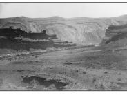
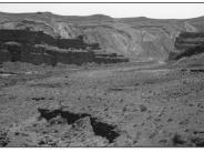
General Description: The view is southeast, down the San Juan River. A mixed land status occurs here with BLM land near the river and private land in the extreme right mid-ground. The Navajo Indian Reservation is located on the far side of the river.
Soils: Upland soils on this site are comprised of Moenkopie or Moenkopie, warm complex. These soils are red very gravelly to sandy loams ranging in depth from only 6 to 9 inches over bedrock. Both soils are moderately to rapidly drained with very low water holding capacities. The riparian zone has not been classified.
Precipitation: A 50 year average annual precipitation rate of 6.50 inches has been recorded at Mexican Hat, Utah some two miles southwest of this site.
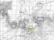
Legal Description: SW1/4SE1/4 Section 32 T.41S., R.19E.
COMPARISON: When comparing the ca. 1895 scene to the 1998 retake, the riparian zone has obviously expanded laterally with little apparent change in bank configurations. This expansion suggests that streambanks and floodplains are retaining more subsurface water for longer periods of time. Riparian plant species including Fremont cottonwood, coyote willow, common reed, horsetail and bulrush have increased in both frequency and total ground cover. Unfortunately, about 50 percent of the total plant composition in the riparian zone consists of extic species, including tamarisk, Russian olive, camelthorn and Russian knapweed. Upland vegetation has apparently increased as well. Frequencies and density of both shrubs and herbaceous species such as shadscale, blackbrush, Mormon tea, fourwing saltbush, snakeweed, Indian ricegrass and curlygrass have increased. Cheatgrass is also present at this location. This improvement has occurred despite the harsh micro-climate existing here. At such stable sites, improvements are slow due to poor soil qualities and low precipitation. Some of the same shrubs appear in both photographs.
Original:
Date: ca. 1895 (- A)
Photographer: Charles Goodman?
Source: University of Utah, Special Collections, Gregory Crampton
Collection
Photograph Number: University of Utah No. 24
Retake:
Date: July 15, 1998 (- B)
Photographer: Earl Hindley
Source: San Juan County


