Bears Ears 2
Data Sheet
BEARS EARS FROM THE EAST
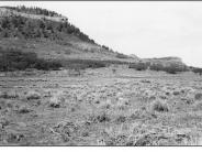
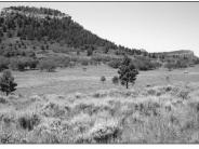
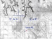
General Description: This westwardly view of the Bears Ears was taken about .4 mile southeast of the junction of South Long Point and main forest access roads. The site is within the Manti-LaSal National Forest. A similar photo comparison appeared in the Forest Service publication, Vegetation Changes on the Manti-LaSal National Forest, published in 1995.
Soils: Deep loam
Precipitation: The average annual precipitation ranges from 16 to 20 inches.
Legal Description: SW1/4NE1/4 Section 29 T.36S., R.19E.
COMPARISON: Favorable soil conditions and precipitation levels at this site are conducive to vegetation and soil surface improvements. This site was mechanically treated and seeded sometime after 1953. Improved plant densities and ground cover are evident by comparing the two photographs. Plant species present include smooth brome, crested wheatgrass, bluegrass species, thickspike wheatgrass, letterman needlegrass, woods rose, yarrow, gambel oak and sagebrush. Conifers on the background mesa have increased with a corresponding decrease in the aspen community at the lower right slope.
Original:
Date: July 21, 1953 (- A)
Photographer: Julian Thomas
Source: U.S. Forest Service, Price, Utah
Photograph Number: Thomas No. 6
Retake:
Date: July 30, 1998 (- B)
Photographer: Earl Hindley
Source: San Juan County


