Bluff, Utah
Data Sheet
BLUFF, UTAH
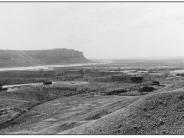
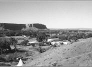
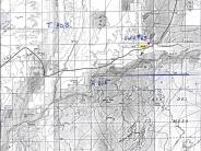
General Description: The view, from the cemetery, is southwest across Bluff, Utah and downstream of the San Juan River. The scene is mostly private land extending from the photopoint to about .25 to .50 mile north of the river where BLM administered land begins.
Precipitation: Seventy years of records taken at Bluff, Utah show an average annual precipitation rate of 6.8 inches.
Legal Description: NW1/4NE1/4 Section 25 T.40S., R21E.
COMPARISON: The original photograph illustrates the small community of Bluff, Utah some 15 years after settlement. The San Juan River is wide and shallow supporting little or no woody riparian vegetation. Some of the original large wood was no doubt cut to provide materials for homes, shelters, dams and corrals. In addition to depicting growth in Bluff, the repeat photograph shows the dramatic increase in the extent and density of large woody riparian species such as Fremont cottonwood, Gooding willow and coyote willow along the San Juan. Exotic woody species, tamarisk and Russian olive, also inhabit the site. The channel has been narrowed and floodplains have established on both sides of the river within the entire view length of the photographs.
Original:
Date: ca. 1895 (- A)
Photographer: Charles Goodman?
Source: University of Utah, Special Collections, Gregory Crampton
Collection
Photograph Number: University of Utah No. 63
Retake:
Date: July 15, 1998 (- B)
Photographer: Earl Hindley
Source: San Juan County


