Cow Canyon
Data Sheet
COW CANYON
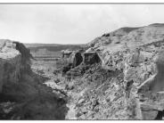
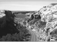
General Description: The view is south down Cow Canyon toward the San Juan River and Bluff, Utah which is about 1 mile southwest of the site. Land status at the immediate location is state property with private lands beginning near the canyon mouth. Bureau of Land Management administered lands are found near the river. Precipitation: Seventy years of records taken at Bluff, Utah show an average annual precipitation rate of 6.8 inches.
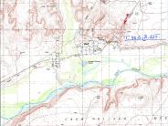
Legal Description: SW1/4NE1/4 Section 19 T.40S., R.22E.
COMPARISON: In addition to obvious changes that have been made to Highway 163, riparian gains are also striking. Significant increases in Fremont cottonwood, Gooding willow and common reed have occurred here since 1925. Other species found in the scene include singleleaf ash, saltgrass, greasewood, alkali sacaton, greasewood, Mormon tea, rabbitbrush and cheatgrass. Exotic woody species, tamarisk and Russian olive have also established since 1925. Obvious vegetation and channel changes have also occurred along the San Juan River. The once wide, somewhat sparsely vegetated channel has narrowed with significant increases in riparian vegetation along the banks and floodplain. Woody species there include Fremont cottonwood, Gooding willow, coyote willow, Russian olive, and tamarisk.
Original:
Date: 1925 (- A)
Photographer: W.T. Lee
Source: U.S. Geological Survey, Denver, Colorado
Photograph Number: Lee No. 3048
Retake:
Date: June 1, 1999 (- B)
Photographer: Earl Hindley
Source: San Juan County


