Indian Creek
Data Sheet
INDIAN CREEK
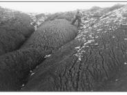
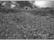
General Description: The view is of a steep south-facing slope which drains to upper Indian Creek. The site is on the Manti-LaSal National Forest and within the Blanding Community Watershed. It is no longer grazed by livestock. A similar photopair appears in a 1995 Forest Service publication, Vegetation Changes on the Manti-LaSal National Forest.
Soils: Heavy clay
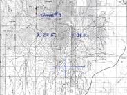
Legal Description: NW1/4SW1/4 Section 3 T.34S., R.34E
COMPARISON: This slope was contour trenched and seeded after the original Thomas photograph. Native and seeded plant species are now well established, providing a significant increase in plant density, ground cover and soil binding capability. The extensive gully system present in the 1940s has been repaired. Some plant species found here include smooth brome, intermediate wheatgrass, needle and thread grass, orchard grass, timothy, groundsel, American vetch, mountain snowberry and currant.
Original:
Date: Late 1940s (- A)
Photographer: Julian Thomas
Source: U.S. Forest Service, Price, Utah
Photograph Number: Thomas No. 3
Retake:
Date: July 29, 1998 (- B)
Photographer: Earl Hindley
Source: San Juan County


