Johnson Creek
Data Sheet
JOHNSON CREEK
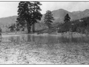
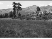
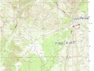
General Description: This photopoint is on a small tributary of Johnson Creek in the Manti-LaSal National Forest. The view is northwest across the Johnson Creek drainage. This area is south of the Blanding Community Watershed and is grazed by cattle.
Soils: Soil in the immediate foreground is a deep water washed sandy clay loam that has been deposited behind a small water impoundment. The site has a good source of both surface and subsurface water.
Precipitation: The average annual precipitation at this location is about 12 inches.
Legal Description: SW1/4SE1/4 Section 28 T.34S., R.22E.
COMPARISON: The shallow pond has been filled with sediment and evolved into a riparian / wetland habitat. Riparian / wetland plants include Nebraska sedge, Baltic rush and slender potentilla. The far end of the pond is more mesic and is populated with timothy, foxtail grass, thickspike wheatgrass, iris and yarrow. Adjacent uplands support gambel oak, currant, snowberry and lupine. A significant increase in conifer densities on the far east facing slope has occurred in the 83 years between photographs.
Original:
Date: 1915 (- A)
Photographer: M.R. Thorpe
Source: University of Utah, Special Collections, H.E. Gregory Collection
Photograph Number: University of Utah No. 9-2131
Retake:
Date: July 29, 1998 (- B)
Photographer: Earl Hindley
Source: San Juan County


