Lower Cottonwood Creek
Data Sheet
LOWER COTTONWOOD CREEK
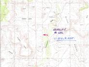
General Description: This photopoint is located .25 mile north of the Decker Ranch road crossing of Cottonwood Wash. The immediate vicinity is private land; the view is west.
Legal Description: SE1/4NW1/4 Section 18 T39S., R.22E.
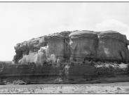
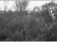
COMPARISON: A diverse age class Fremont cottonwood community has established here since Gregory’s 1932 photograph. The raw vertical banks, visible in 1932, have somewhat evolved to a more gentle grade and a mixture of upland and riparian plant species have established there. The once wide channel has now been reduced to a width of 20 feet. Photograph -C (not shown) illustrates the downstream channel cross section at this point. Some other species present include coyote willow, spike rush, Baltic rush, yellow sweetclover, sagebrush and rabbitbrush. Exotic species such as cheatgrass and tamarisk are also present. Tamarisk is mostly found on the second terrace and is not a dominant species. Cottonwood Wash is an intermittent stream at this point. Without a constant supply of free water the rate and extent of future riparian development is somewhat limited.
Original:
Date: 1932 (- A)
Photographer: H.E. Gregory
Source: U.S. Geological Survey, Denver, Colorado
Photograph Number: Gregory No. 692
Retake:
Date: June 2, 1999 (- B)
Photographer: Earl Hindley
Source: San Juan County


