Near Monticello Lake
Data Sheet
NEAR MONTICELLO LAKE
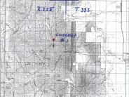
General Description: This photopoint is in the Manti-LaSal National Forest some .2 mile south of Monticello Lake. The view is south from near the Monticello / Indian Creek Highway. A similar photo comparison appeared in a Forest Service publication, Vegetation Changes on the Manti-LaSal National Forest, published in 1995.
Soils: Deep heavy clay soils are found on the site.
Precipitation: The average annual precipitation ranges from 16 to 20 inches.
Legal Description: NW1/4SE1/4 Section 23 T.33S., R22E.
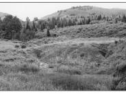
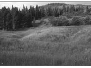
COMPARISON: In 1957, the foreground area appeared to be dry with several apparently active gullies present. The area visible in the upper right mid-slope was contoured after the original photograph. Soils, precipitation levels and subsurface water availability such as those found on this site permit improvements. The foreground is now a wet meadow with much improved plant densities and cover. The site is now stable and the gullies have healed. Plant species present include smooth brome, thickspike wheatgrass, timothy, sedge species, rush species, horsetail and iris. Vegetation on the contoured area includes smooth brome, intermediate wheatgrass, mountain snowberry, gambel oak and a few bull thistle plants.
Original:
Date: July 17, 1957 (- A)
Photographer: Simon L. Cuskelly
Source: U.S. Forest Service, Price, Utah
Photograph Number: Cuskelly No. 1
Retake:
Date: July 30, 1998 (- B)
Photographer: Earl Hindley
Source: San Juan County


