Valley of the Gods 1
Data Sheet
VALLEY OF THE GODS
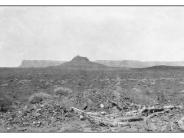
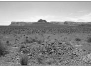
General Description: This photo is one of a series depicting development in the Goodridge Oil Field. The view is west toward Bell Butte and across public land administered by BLM.
Soils: Soils at this site are comprised of Moenkopie or Moenkopie warm complex. They are red very gravelly to sandy loams ranging in depth from only 6 to 9 inches over bedrock. Both soils are moderately to rapidly drained with very low water holding capacities.
Precipitation: A fifty year average annual precipitation of 6.50 inches has been recorded at Mexican Hat, Utah, some 6 miles south of this photopoint.
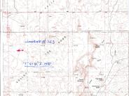
Legal Description: NE1/4NW1/4 Section 7 T.41S., R.19E.
COMPARISON: This harsh site does not seem to have appreciably changed in the 89 years between photographs. The same plant species, apparently some of the same plants, at similar frequencies are present in 1999. Possibly a few of the shadscale and wolfberry plants have been replaced by blackbrush. Because of the low precipitation and shallow, relatively unproductive soils that exist here, the site may be in a stable state. As such, improvements such as change in vegetation composition and frequencies are slow to occur. Some other plant species that occur here include Mormon tea, snakeweed, curlygrass, globemallow and prickly poppy. Some drilling operation litter can still be found on the site.
Original:
Date: ca. 1910 (- A)
Photographer: E.G. Woodruff
Source: U.S. Geological Survey, Denver Colorado
Photograph Number: Woodruff No. 163
Retake:
Date: June 3, 1999 (- B)
Photographer: Earl Hindley
Source: San Juan County


