Bears Ears 1
Data Sheet
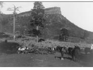
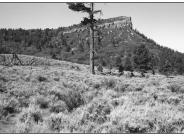
BEARS EARS FROM THE NORTH
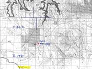
General Description: The view here is to the southwest from a point approximately .4 mile northwest of Bears Ears Pass. The site is within the Manti-LaSal National Forest.
Soils: Deep loam.
Precipitation: 16 to 20 inches annually.
Legal Description: NW1/4 Section 30 T.36S., R.19W.
COMPARISON: Conifers have increased in the mountain shrub zone. The denuded forground area has improved to the point where the site has nearly 100 percent plant cover with plant species such as sage brush, sandberg bluegrass, thickspike wheatgrass, intermediate wheatgrass (introduced), sagebrush, mountain snowberry and slender cinquefoil. A narrow wet zone has developed immediately behind the photopoint.
Original:
Date: June 1915 (- A)
Photographer: M.R. Thorpe?
Source: University of Utah, Special Collections, H.E. Gregory Collection
Photograph Number: University of Utah No. 9-1387
Retake:
Date: July 16, 1998 (- B)
Photographer: Earl Hindley
Source: San Juan County


