Arch Canyon 2
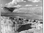
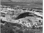
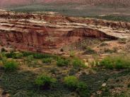
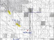
General Description: This photo-point is on the south rim of Arch Canyon approximately one half mile upstream from it mouth. The view is northeast across Arch Canyon and Comb Wash.
Legal Description: NE1/4NE1/4 Section 26 T.37S., R.20E.
COMPARISON: Vegetation density and diversity has increased along the Arch Canyon stream channel in the 35 to 38 years between the two photographs. Riparian plant species now present include Fremont cottonwood, coyote willow, yellow willow, bulrush, common reed, cattail, Baltic rush and a few tamarisk plants. The stream channel is now much more narrow, is developing sinuosity and is properly functioning.
A significant difference in vegetation and stream channel characteristics on the main stem of Comb Wash is visible in the mid-portion of the photographs. The channel is much more narrow and is supporting a more dense vegetation cover.
| Original: Date: ca. 1960 (- A) Photographer: Parker Hamilton Source: Utah State Historical Society Photograph Number: USHS No. 17387 |
1998 Retake: Date: July 15, 1998 (- B) Photographer: Earl Hindley Source: Bureau of Land Management, Salt Lake City, Utah |
2007 Data
2007 Retake:
Date: April 26, 2007
Photographer: Earl Hindley
Source: Earl Hindley
General
Description:
The photo-site is on a rocky ledge on the south side of Arch Canyon approximately one half mile from its mouth.
Location:
N. 37 32.652’ W. 109
40.469’ (Lat./Long.)
Comments/Comparison: High water flow in 2006 deposited significant amounts of sandy soil as well as cutting several new overflow channels in the entire visible flood plain across the bottom of the 2007 photograph (note accompanying photos A, B and C which were taken in the canyon just left of view area). The main channel was rerouted from the south to the north in an area near the alcove. This stream reach has developed a significant riparian community since the ca. 1960 photograph was taken. The development is apparent when the 1960 photograph is compared with the 1998 photograph. This development has continued from 1998 where the willow community is maturing and expanding laterally. The common reed (Phragmites), rush, cattail community had expanded significantly to the south by 2007.
Riparian vegetation including willows, cottonwoods, common reed, cattail and rushes have become firmly established here which in turn created a distinct flood plain and narrowing of the channel by capturing sediments from previous water flows. This narrower channel (see accompanying photograph D) cannot accommodate the high water flow which this drainage is capable of producing and contributed to over bank flooding of 2006. (Feb. 2007)
The April 2007 photographs clearly show where Arch Creek’s main channel has been rerouted from south to north since the earlier photographs were taken from this location. However, water still flows in the earlier (southern channel).
The accompanying photographs A, B, C and D. all illustrate the emergence of new riparian plant specie growth since the floods of 2006. (April 2007)


