Comb Wash 3 (near Snake Canyon)
Data Sheet
COMB WASH NEAR SNAKE CANYON
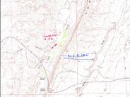
General Description: This photopoint is on BLM administered land on the west side of Comb Wash about .6 of a mile north of the Comb Wash road and Highway 163 junction. The view is northeast along the west face of Comb Ridge.
Legal Description: NE1/4SW1/4 Section 26 T.40S., R.20E.
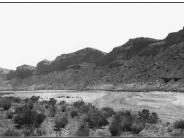
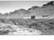
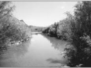
COMPARISON: The 1910 Woodruff photograph is a very early image of Comb Wash. It depicts a wide, shallow and braided channel with little, if any, riparian vegetation. The active channel width here is about 900 feet. The 1999 image reveals a much narrower channel with a main stem and overflow channels. The active channel now has a width measuring from 20-30 feet. Three floodplain terraces have developed. Vegetation on the second and third terrace consists mainly of tamarisk, greasewood, rabbitbrush, a few Fremont cottonwood trees, grass and forb species. Streambanks and the first terrace are occupied by a surprising number of other riparian plant species, including coyote will, Fremont cottonwood seedlings and poles, spikerush, bulrush, saltgrass, scratchgrass and Bermuda grass (an exotic specie). Comb Wash is an intermittent stream at this point and riparian development will be correspondingly slow. However, vast improvements have occurred in the diversity, frequency and density of the vegetation community and channel configuration at this point in the 89 years between photographs. Photograph -C illustrates a 1999 down-stream view of the channel just east of the photopoint, note the various age classes and specie mix along the stream bank.
Original:
Date: ca. July, 1910 (-A)
Photographer: E.G. Woodruff
Source: U.S. Geological Survey, Denver, Colorado
Photograph Number: Woodruff No. 178
Retake:
Date: September 6, 1999 (-B)
Photographer: Earl Hindley
Source: San Juan County


