Cooley Gulch
Data Sheet
COOLEY GULCH
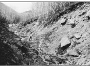
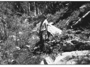
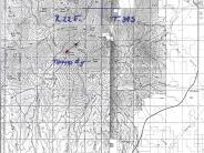
General Description: This site is within the Manti-LaSal National Forest and the Blanding Community Watershed. It is no longer grazed by livestock. The view is upstream in Cooley Gulch about .1 mile upstream from where the gulch crosses the main forest access road. A similar photopair appeared in a 1995 Forest Service publication, Vegetative Changes on the Manti-LaSal National Forest.
Legal Description: NE1/4SE1/4 Section 15 T.34S., R.22E.
COMPARISON: Orientation can be gained from the large somewhat square rock that appears in the upper left hand portion of the 1940s photograph. The same rock can be seen slightly toward the upper center of the 1998 photograph. This approximately relocated scene shows a dramatic improvement and a properly functioning system. The once raw streambanks have stabilized with new aspen growth and the establishment of riparian vegetation such as willows, sedges, yellow monkey flower, and cow parsnip. The channel is slowly aggrading.
Original:
Date: ca. late 1940s (- A)
Photographer: Julian Thomas
Source: U.S. Forest Service, Price, Utah
Photograph Number: Thomas No. 5
Retake:
Date: July 29, 1998 (- B)
Photographer: Earl Hindley
Source: San Juan County


