Dark Canyon
Data Sheet
DARK CANYON
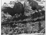
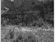
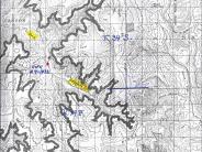
General Description: The view is downstream in Dark Canyon at a point approximately ½ mile above the mouth of Rig Canyon. This site is within the Dark Canyon Wilderness Area administered by the U.S. Forest Service.
Legal Description: SW1/4NW1/4 Section 29 T.34S., R.19E.
COMPARISON: Vegetation and stream bank trends are definitely improving at this site. Streambanks, poorly vegetated in 1927, now support a good variety of riparian plant species including narrowleaf cottonwood, coyote willow, sedges and horsetail. The channel, much narrower in 1998 as compared to 1927, is beginning to form meanders and a substantial floodplain. Note that some of the same cottonwood and ponderosa pine trees visible in 1927 are still present in 1998.
Original:
Date: ca. 1927 (- A)
Photographer: H.E. Gregory
Source: University of Utah, Special collections, H.E. Gregory Collection
Photograph Number: University of Utah No. 9-1838
Retake:
Date: July 31, 1998 (- B)
Photographer: Earl Hindley
Source: San Juan County


