Dry Valley 1
Data Sheet
DRY VALLEY
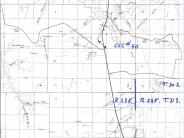
General Description: This photopoint is located about .1 mile north of the junction of highway 163 and the road to the Canyon Rims overlook. It is on the east side of the highway and outside of the fenced right-of-way. The view is northwest across land administered by BLM.
Soils: Soils at the site are Windwhistle-Sazi very fine sandy loams. These soils are moderately deep and well drained. Effective rooting depths of these soils range from 20 to 40 inches.
Precipitation: Estimated average precipitation is 9 to 11 inches.
Legal Description: SE1/4SE1/4 Section 15 T.30S., R.23E..
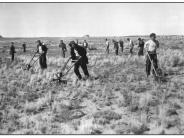
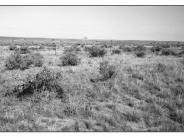
COMPARISON: The 1940 photograph depicts a CCC re-seeding project. A healthy and diverse plant community has developed here in the 59 years between photographs. Shrub frequencies have increased and cover has increased as the fourwing saltbush and shadscale plants have matured. Threeawn grass has been mostly replaced by more productive species such as Indian ricegrass and needle and thread grass. Overall plant cover has increased as evidenced by a decrease in interspace size and frequency. Some of the other plant species on site include Mormon tea, winterfat, rabbitbrush, snakeweed, squirreltail, curly grass, blue grama and globemallow. Exotic species such as cheatgrass and storksbill are also present. Vegetation conditions inside of the fenced right-of-way (visible in the 1998 photograph about 75 feet from the photopoint) are very similar to the foreground area that is still grazed by cattle. The deep sandy loams found here are moderately productive if an annual precipitation level of about 10 inches is maintained.
Original:
Date: October 25, 1940 (- A)
Photographer: Unknown
Source: Bureau of Land Management, Salt Lake City, Utah
Photograph Number: CCC No. 40
Retake:
Date: September 18, 1998 (- B)
Photographer: Earl Hindley
Source: San Juan County


