Dry Valley 2 (near Deer Neck Mesa)
Data Sheet
DRY VALLEY NEAR DEER NECK MESA
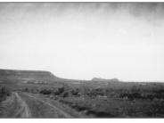
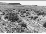
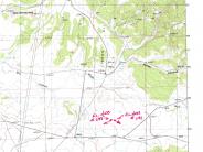
General Description: This west southwest view is of Dry Valley near Big Indian Wash and Deer Neck Mesa. The area is public land administered by the Bureau of Land Management. Hess’ original photograph is in relatively poor condition making comparison somewhat difficult.
Soils: Deep Begay fine sandy loams are found on the site. These soils have effective root depths of over 60 inches with moderately rapid permeability.
Precipitation: Average annual precipitation is about 12 inches.
Legal Description: NE1/4SW1/4 Section 27 T.30S., R.24E.
COMPARISON: Since 1924, there has been an obvious improvement in plant health and vigor, resulting in higher plant frequencies and ground cover. In 1994 only three plant species were found on the site, big sagebrush, snakeweed and blue grama. The small pinyon-juniper community visible in the background has not changed in the 70 years between photographs.
Original:
Date: June 25, 1924 (- A)
Photographer: F.L. Hess
Source: U.S. Geological Survey, Denver, Colorado
Photograph Number: Hess No. 1146
Retake:
Date: August 3, 1994 (- B)
Photographer: Earl Hindley
Source: Bureau of Land Management, Salt Lake City, Utah General


