Grey Mesa
Data Sheet
GREY MESA
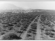
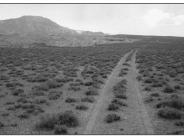
General Description: This southwest view was taken near the northern end of Grey Mesa. The road is what remains of the trail blazed by Hole-in-the-Rock pioneers in the winter of 1879-80. The area is now within the Glen Canyon National Recreation Area.
Soils: Grey Mesa is comprised of Bluechief sandy loam soils that are moderately deep, well drained with a low water supplying capacity. They are positioned over limestone bedrock. Although they have a potential rooting depth of up to 40 inches, most Bluechief soils on Grey Mesa do not exceed 26-30 inches to bedrock.
Precipitation: Grey Mesa receives from 6-8 inches precipitation annually.
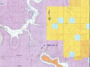
Legal Description: SW1/4SE1/4 Section 21 T.40S., R.11E.
COMPARISON: Grey Mesa is where Hole-in-the-Rock pioneers had one of their few disagreements in 1879-80. A rather severe argument occurred here resulting from a shortage of forage for company livestock. One part of the group was forced to move their animals further along the trail in order that all would not starve (Miller 1959). The mesa top is in a stable state with little or no potential for change. Comparison of the 1962 and 1998 images reveals little, if any, change in vegetation or soil surface conditions in the 36 years between these two photographs. Many of the same blackbrush and thorny milkwort plants, visible in 1962 still occupy the site in 1998. Overall plant densities and cover are approximately the same in both images. Some of the other plant species occurring here include Mormon tea, snakeweed, buckwheat, cutleaf heliotrope, Indian ricegrass, curlygrass and the exotic red brome.
Original:
Date: ca. 1962 (- A)
Photographer: Kent Frost
Source: Kent Frost, Monticello, Utah
Photograph Number: Frost No. 11
Retake:
Date: September 16, 1998 (- B)
Photographer: Earl Hindley
Source: San Juan County


