Hatch Wash
Data Sheet
HATCH WASH
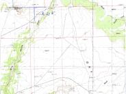
General Description: This photopoint is near the confluence of Hatch Wash and Joe Wilson Canyon. The view is west southwest toward Hatch Rock. The immediate foreground is private land that is unfenced from the public lands administered by BLM and State of Utah that surround it.
Legal Description: NE1/4SE1/4 Section 31 T.29S., R.23E.
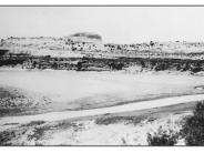
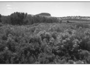
COMPARISON: The 1915 image of Hatch Wash shows a broad, braided channel with vertical banks. The entire channel is devoid of vegetation. By 1998 this stream segment has improved to a point where banks have evolved to a sloped condition, the channel has narrowed and a floodplain with two terraces has developed. A thick mixture of native riparian species and tamarisk have occupied the site. Native riparian species include Fremont cottonwood, coyote willow, bulrush, cattail and Baltic rush. Other plants that occur on the terrace areas include saltgrass, rabbitbrush and greasewood. Fremont cottonwood trees are forming a gallery and becoming dominant on the terrace at the left of the scene.
Original:
Date: ca. June 28, 1915 (- A)
Photographer: H.E. Gregory
Source: University of Utah Special Collections, H.E. Gregory Collection
Photograph Number: University of Utah No. 9-1382
Retake:
Date: July 13, 1998 (- B)
Photographer: Earl Hindley
Source: San Juan County


