Mexican Hat Rock
Data Sheet
MEXICAN HAT ROCK
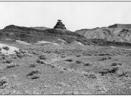
General Description: This view of Mexican Hat Rock, taken to the northeast, was made by Nevills as part of the Depression Era Utah Writer’s Project. The immediate foreground is private land with BLM administered land in the background.
Soils: Soils at this site are classified as Moenkopie or Moenkopie warm complex. They are red and very gravelly to sandy loams ranging from only 6-9 inches deep over bedrock. Both soils are moderately to rapidly drained with very low water holding capacities.
Precipitation: A 50 year precipitation average from Mexican Hat, about one mile south of this site, is 6.5 inches.
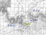
Legal Description: NE1/4NE1/4 Section 6 T.42S., R.19E.
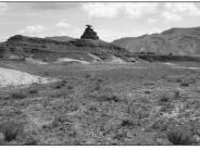
COMPARISON: There appears to have been a decrease in shadscale plants with a corresponding increase in grasses such as cheatgrass, Indian ricegrass and curlygrass, resulting in a slight increase in plant soil cover. The rills and small gullies visible in the 1930’s photograph have healed and they are not as evident in 1995. The shallow Moenkopie derived soils and a 6.50 average annual precipitation level makes this a harsh range site. Improvements are slow in such areas. Considerable off-highway vehicle use in the general area is causing soil disturbance and loss of vegetation cover.
Original:
Date: ca. 1930’s (- A)
Photographer: Norman Nevills
Source: Utah State Historical Society, Salt Lake City, Utah
Photograph Number: Utah State Historical Society No. 10800
Retake:
Date: July 24, 1998 (- B)
Photographer: Earl Hindley
Source: San Juan County


