Montezuma Creek
Data Sheet
MONTEZUMA CREEK
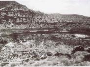
General Description: The 1875 Jackson photograph was taken just before large numbers of livestock were introduced into San Juan County. The view is south over ancient Anasazi ruins at the confluence of Coal Bed Creek and Montezuma Creek. Montezuma Creek enters the scene from the right. The original photograph shows the ruins on a rocky outcrop that immediately drops to a flood plain terrace that was probably farmed. The site is mixed ownership between the State of Utah and Bureau of Land Management.
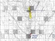
Legal Description: SE1/4NE1/4 Section 2 T.37S., R.24E.
COMPARISON: Vegetation on the 1875 floodplain is difficult to identify. What appears to be willow plants are found in the lower left of the scene, while willow and cottonwoods seem to inhabit banks of Montezuma Creek at the right. Other floodplain vegetation is unknown but may consist of common reed, willow, cattail or even wild rye. What may be corn stalks appear in the open space located at the right center of the original image. A corn field image with similar growth characteristics is found on page 26 of The Museum of Northern Arizona’s Spring 1995 Canon Journal issue. Jackson observed that Montezuma Wash was dry when he made the photograph. He also drew particular attention to the “series of large stones set upon end and projecting 5-7 feet above the surface.”
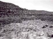
The 1998 retake clearly shows that the 1975 floodplain has been mostly lost to downcutting and entrenchment of both Coal Bed and Montezuma Creeks. The available record does not allow specific dating of the downcutting. However, research conducted on other sites in southern Utah and northern Arizona (Gregory 1950 and Webb et al. 1991) indicates that major stream degradations occurred in this region beginning in the 1870’s and 1880’s. The retake clearly shows that both channels now support several age classes of Fremont cottonwood and willow. Both channels also support good populations of Gooding willow, yellow willow, coyote willow, cattail, rush species and bulrush. A few tamarisk plants can also be found but they are not a major component of the vegetation community. Both channels are in properly functioning condition as they are aggrading and riparian habitats are expanding. vegetation conditions in the foreground appear to have changed little since 1875. Greasewood, shadscale, snakeweed and sagebrush are still present. Cheatgrass and the two juniper trees at the left are new.
Original:
Date: 1875 (- A)
Photographer: William
Henry Jackson
Source: U.S. Geological Survey, Denver, Colorado
Photograph Number:
Jackson No. 534
Retake:
Date: July 22, 1998
Photographer: Earl Hindley
Source: San Juan County


