Near La Sal Junction
Data Sheet
NEAR LASAL JUNCTION
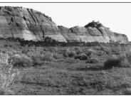
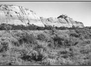
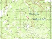
General Description: This photo point is found on the east side of the highway 163 right-of-way fence at a point .75 mile north of the oil pipeline pumping plant at LaSal Junction. The view is south southeast across public land administered by the Bureau of Land Management.
Soils: Two soil types are found at this site. Ignacio-Leanto fine sandy loam soils occupy the foreground. These soils are fine sandy loams with moderately rapid permeability. Depths to bedrock range from 10 to 40 inches. Soils in the mid-ground (to the bottom of the hill) are Mido loamy fine sands. These soils are very deep, over 60 inches, with a rapid permeability and a low water supplying capacity.
Precipitation: Average annual precipitation at this point ranges from 10 to 12 inches.
Legal Description: SW1/4NE1/4 Section 30 T.28S., R.23E.
COMPARISON: When comparing the 1913 and the 1999 images, it is obvious that there has been an increase in plant diversity and frequency resulting in a much healthier community with increased protective ground cover. Some plant species present in 1999 include big sagebrush, fourwing saltbush, snakeweed, Indian ricegrass, sand dropseed, curlygrass, threeawn and globemallow. Cheatgrass and Russian thistle are also found here. The pinyon-juniper community near the hill has expanded since 1913.
Original:
Date: October 14, 1913 (- A)
Photographer: F.L. Hess
Source: U.S. Geological Survey, Denver, Colorado
Photograph Number: Hess No. 573
Retake:
Date: September 5, 1999 (- B)
Photographer: Earl Hindley
Source: San Juan County


