Pagahrit Lake
Data Sheet
PAGAHRIT LAKE
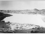
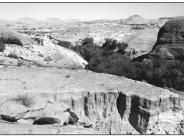
General Description: Pagahrit Lake (sometimes referred to as Hermit Lake) was formed by a large sand dam across what is now Lake Canyon. The structure was located downstream at the upper left side of the 1895 photograph and is not visible. Hole-in-the-Rock pioneers camped at this lake in 1880 and crossed Lake Canyon on the sand dam. The dam washed out in 1915. The view is north northeast across the canyon. The surrounding area is public land administered by the Bureau of Land Management.
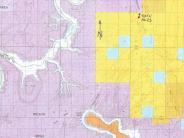
Legal Description: SW1/4NE1/4 Section 19 T.39S., R.12E.
COMPARISON: Goodman’s photograph was apparently taken during the winter or early spring. Note the absence of leaves on the cottonwood trees on the far lake bank. Obviously, the most striking contrast between 1895 and 1998 is due to the dam failure and resulting downcutting of stream deposited sediments (foreground). However a substantial and diverse riparian community has developed in Lake Canyon. A few of the riparian plant species now present include fremont cottonwood, Gooding willow, coyote willow, Baltic rush, cattail, common reed, bulrush and white virgin’s bower. A few tamarisk plants are also found. Remains of the 1895 cottonwood gallery can still be found.
Original:
Date: ca. 1895 (- A)
Photographer: Charles Goodman
Source: University of Utah Special Collections, Dick Beck Collection
Photograph Number: University of Utah No. 23
Retake:
Date: September 15, 1998 (- B)
Photographer: Earl Hindley
Source: San Juan County


