Recapture Creek
RECAPTURE CREEK
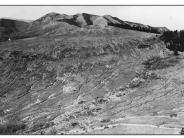
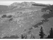
General Description: This northwest view of the head of Recapture Creek is within the Manti-LaSal National Forest. This immediate area is part of the Blanding Community Watershed and is no longer grazed by livestock. A similar photopair appears in a 1995 Forest Service publication titled Vegetation Changes on the Manti-LaSal National Forest.
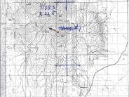
Legal Description: SE1/4SW1/4 Section 13 T.34S., R.22E.
COMPARISON: The contour trenching and seeding project, completed after the Thomas photograph, has stabilized the slope. Gully erosion has been curtailed and the area continues to heal. Good varieties of introduced and native plants have become firmly established on the slope as well as in the draw.
Original:
Date: ca. late 1940s or early 1950s (- A)
Photographer: Julian Thomas
Source: U.S. Forest Service, Price, Utah
Photograph Number: Thomas No. 1
Retake:
Date: July 29, 1998 (- B)
Photographer: Earl Hindley
Source: San Juan County


